Soil carbon farming pre-feasibility in Southwest Friesland
A preliminary spatial assessment of grassland and soil organic carbon to support carbon farming project development in the Netherlands.
Objective
Identify grassland overlapping mapped mineral soil units and describe existing soil organic carbon (SOC) stocks as an initial step toward evaluating a carbon farming project.
The assessment uses the European Carbon Removals and Carbon Farming Certification Framework (CRCF) as a reference for project development. It does not establish certification eligibility or generate carbon credits.
Workflow
- Define the study area in southwest Friesland.
- Map grassland using ESA WorldCover 2021.
- Classify soil units using the Dutch BRO soil map.
- Identify grassland overlapping mineral soil groups, separating peat and organic-rich soil groups.
- Summarise SoilGrids SOC stocks at 0–30 cm and produce a two-panel map in QGIS.
Tools: Google Earth Engine · QGIS · Spatial analysis · Zonal statistics
Main results
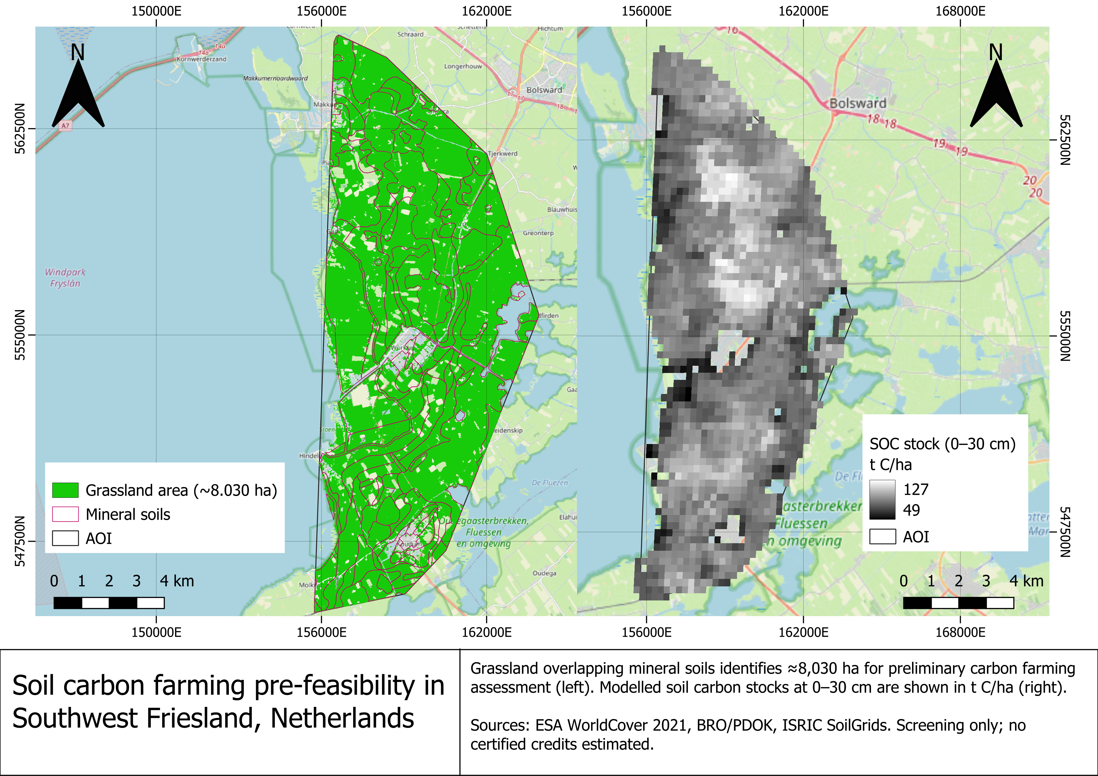
Approximately 8,030 ha of grassland overlap soil groups selected for preliminary mineral-soil screening.
| Soil group | Grassland area (ha) | Mean SOC stock (t C/ha)* |
|---|---|---|
| Marine clay soils | 7,200.77 | 89.9 |
| Calcareous sandy soils | 585.07 | 85.0 |
| Podzol soils | 221.40 | 85.2 |
| Glacial till soils | 22.54 | 82.9 |
| Total screening area | 8,029.78 | — |
SOC means describe valid SoilGrids pixels across each mapped soil group, not exclusively its grassland.
The left panel shows grassland and mapped mineral soil units used for screening. The right panel displays modelled SOC stocks, ranging from 49 to 127 t C/ha across the study area.
Connection to carbon project development
A potential follow-up would evaluate improved grassland management, such as sward diversification and adjusted fertiliser management.
Developing this concept into a carbon project would require:
- Baseline: document current management and expected emissions and removals without the project.
- Additionality: demonstrate that proposed improvements go beyond the baseline and applicable requirements.
- Monitoring and verification: establish field soil sampling, management records and repeated measurements under an applicable methodology.
CRCF is an EU framework for voluntary certification; this assessment does not demonstrate eligibility for EU ETS compliance.
Limitations
SoilGrids provides modelled stocks at approximately 250 m resolution. Existing carbon stocks are not estimates of additional sequestration or tradable credits.
Mapped soil groups provide a screening proxy: organic horizons, current management and site eligibility require field verification. This project is a desktop pre-feasibility exercise.
Data sources
- ISRIC SoilGrids — soil organic carbon stocks, 0–30 cm.
- ESA WorldCover 2021 — land cover at 10 m resolution.
- BRO Bodemkaart / PDOK — Dutch soil map.
- EU CRCF Regulation — certification framework.
- © OpenStreetMap contributors — basemap.
© ESA WorldCover project 2021 / Contains modified Copernicus Sentinel data (2021) processed by ESA WorldCover consortium